Our first major project of the year used geography as a vehicle to address the larger skills of initiating inquiry, carrying out research, and creation of an original product to demonstrate understanding. In the process, students discovered that geography is much more than they had once believed. The entire activity is available here.
As students brainstormed questions an initial realization set in; often composing a quality question is more difficult than answering one. Inquiry requires prior knowledge and a high level of engagement, therefore it is essential that students have a topic they are both interested in and already know a little about. Each year topics are as diverse as the interests in the classroom, ranging from sports to food to music to war. Almost no topics are off limits because everything is geographic. Everything has a location associated with it, and the phenomena of locations can always be compared and contrasted with the phenomena of another. In other words, geography is not just about "where?" something is, it is more about "why?".
This notion of geography contrasts sharply with the practice of studying locations by memorizing where they are, what they are named, and what the capitals is. Truth be told, I can't let go of that idea completely. As students are working on the rich learning of the Geographic Inquiry, I have them essentially memorizing a map of American geographic features, mainly states and capitals. Teachers should constantly be asking themselves questions such as: why do I spend time on particular content? What do students really need to know? What makes this important? In my classroom place-name geography serves a citizenship goal more than a geography goal. I believe it is important for American citizens to have a basic knowledge of the important locations in our country. I am willing to dedicate a certain amount of time to this goal, but favor the learning that takes place with more open ended inquiry and a deep, meaningful exploration of a topic.
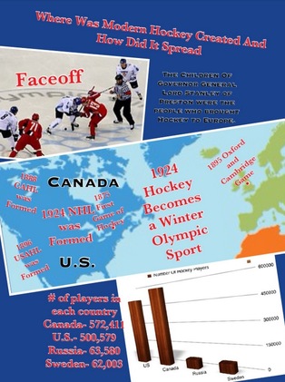
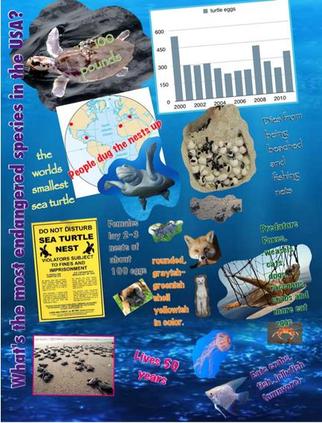
The final stage of the Geographic Inquiry is to create an info-graphic to show others what was learned in the process. This year we used an iPad app called Pic Collage in combination with other apps to create these products. Students did have some guidelines such as it needed to have a map, represent data in some way, etc, but design was largely left to the individual student.
Recently, as students shared their info-graphics in class, I was impressed with the quality, creativity, and originality of the work, but also the knowledge students students had constructed. Some of the learning was about the topic that they had personally chosen, but the big ideas of the Geographic Inquiry were also clearly present in their work.
We will build on this experience of initiating inquiry throughout the year. Asking quality questions is a critical skill along with locating and managing the information needed to construct an original answer. As our concept of geography has changed, perhaps the way we look at civics and history will follow.
We will build on this experience of initiating inquiry throughout the year. Asking quality questions is a critical skill along with locating and managing the information needed to construct an original answer. As our concept of geography has changed, perhaps the way we look at civics and history will follow.


 RSS Feed